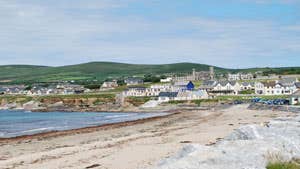
Get ready to be let in on the best-kept secret in the Kingdom. The North Kerry Way is a local’s favourite walking trail that cuts a linear path up the coast through northwest County Kerry, from the lively country town of Tralee to the breezy village of Ballyheigue with its Blue Flag beach.
Tracking through unspoilt countryside and incorporating fascinating historical sites and astonishing mountain and seascapes alike, this well-signed route offers much for the walker with an average level of fitness to enjoy, the best of which has to be the unmatched views over the Dingle Penninsula.
Underfoot, the going is varied yet mostly flat, consisting of peaceful country roads, sandy beach tracks, bog paths, rocky trails and fields. Some climbing near the end, over the Maulin and Triskmore mountains, rewards walkers with unforgettable panoramas as far as Mount Brandon and the Slieve Mish range.
Trail details
- Type:
- Long Distance Waymarked Way
- Location:
- Tralee Ballyheigue
- Grade:
- Moderate
- Format:
- Linear
- Length:
- 43.70km
- Ascent:
- 450m
- Dogs allowed:
- Yes
At Start - charge for street parking, off-street parking in car park opposite Brandon Hotel in Princes Street (not during Rose of Tralee Festival)
At End - in beach car park in Ballyheigue
- Some short, looped walks split off from the main trail at marked points, offering even more to explore.
- For the adventurer, wild camping is permitted along the North Kerry Way, while Woodlands campsite in Tralee is an area favourite. There is also a range of B&Bs in the vicinity.
- The Kerry Head peninsula is steeped in local lore and legend, and there’s no end to the plethora of archaeological sites, castle ruins, forts and more for history lovers to sink their teeth into. Take the short detour at Glendalhin on Kerry Head and head toward the sea, where you can explore the holy well of Tobar na Sul (Spring of the Eyes) and the ruins of Saint Dahalin's church.
