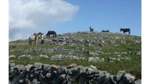
The Burren is an area of scenic attractions where stone-grey hills and the valleys beneath reveal many prehistoric remains. The unfolding layers of limestone form terraces on the slopes of the hills – an the place has been described as a limestone desert! The grey heights are relieved by streaks of coloured vegetation contained in the fissures and rock joints. With its innate sense of spiritual peace, extraordinary array of flora and wildlife, and megalithic tombs and monuments older than Egypt's pyramids.
Carron Loop is a 9.3km walk through a mix of minor roads, animal tracks and green lanes.
Directions to Trailhead:
A-B. Leaving the trailhead at Cassidy’s Pub, follow the green (and purple) arrows downhill past the church and Primary School. The green arrows are for the shorter Templecronan Loop. After 600m, turn right onto a laneway towards Templecronan Church.
B-C. Continue to follow the green and purple arrows to the end of the laneway where both loops enter a field via a stone stile. The two loops diverge here – the green loop veers right toward Templecronan Chuch, you follow the purple arrows as the loop turns left. [Note: You are quite close to the site of Templecronan Church here – if you visit it, remember to return to this junction.]
C-D. The loop now joins a tractor trail and ascends onto the western shoulder of Termon. At the top of the ascent the loop joins a stone wall which is a feature of this beautiful landscape.
D-E. Keeping the long stone wall on your left, the loop crosses a number of smaller stone walls to reach the top of the Clab Valley and turns sharp right.
E-F. Now the loop follows the top edge of Clab Valley (on your left) and after crossing through some stone stiles descends to reach St Fachtnan’s Holy Well.
F-G. From the well the loop travels through fields of stone slab and hazel parallel to a surfaced roadway (on your left) and joins the roadway near the Carran Research Station. Just before joining the roadway, the loop is rejoined (from your right) by the Templecronan Loop. The loop follows the tarred surface for approximately 300m before turning left onto an old laneway.
G-A. The laneway takes you towards a ‘turlough’ (an area which floods annually in wintertime but disappears in Summer). A short uphill trek takes you onto the main road within 100m of the trailhead.
Trail details
- Type:
- Walking Trail
- Location:
- Carran Loops
- Grade:
- Strenuous
- Format:
- Loop
- Length:
- 9.30km
- Ascent:
- 100m
- Dogs allowed:
- No
