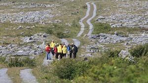
Stretching from coastal Lahinch across the beautiful Burren to the riverside village of Corofin, this linear route takes five days to complete.
The terrain is a moderate mix of green roads, quiet tarmac roads, forestry tracks and ancient cattle droving roads. Some sections do encounter busy roads and some short steep climbs also occur on the trail, which ascends 540m in total.
En route you’ll embrace the Wild Atlantic Way’s rugged charm along the Lahinch and Doolin coastlines. Inland, you’ll skirt Slieve Elva, admire wildflowers sprouting from limestone crevices and spot early Christian churches ruins too.
Towns like Lisdoonvarna and Ballyvaughan guide you across the Clare landscape before you traverse right into the Burren heartland through the villages of Carran and Corofin.
Boasting incredible expanses of coastal, mountain and limestone landscape, at the route’s six trailheads you’ll find warm welcomes and lots of dining options.
Trail details
- Type:
- Long Distance Waymarked Way
- Location:
- Burren Lahinch Corofin
- Grade:
- Moderate
- Format:
- Linear
- Length:
- 118.80km
- Ascent:
- 540m
- Dogs allowed:
- No
- The renowned Cliffs of Moher are just 8km from The Burren Way’s Doolin trailhead. Some of the highest sea cliffs in Europe, the views over the Aran Islands, Galway Bay and the Atlantic itself, are sensational.
